Page 1 of 1
Retouched photo
Posted: Fri May 25, 2012, 8:50 pm
by Jean Raby Nelson
I love this photo
Posted: Fri May 25, 2012, 9:46 pm
by Bruce Osburn
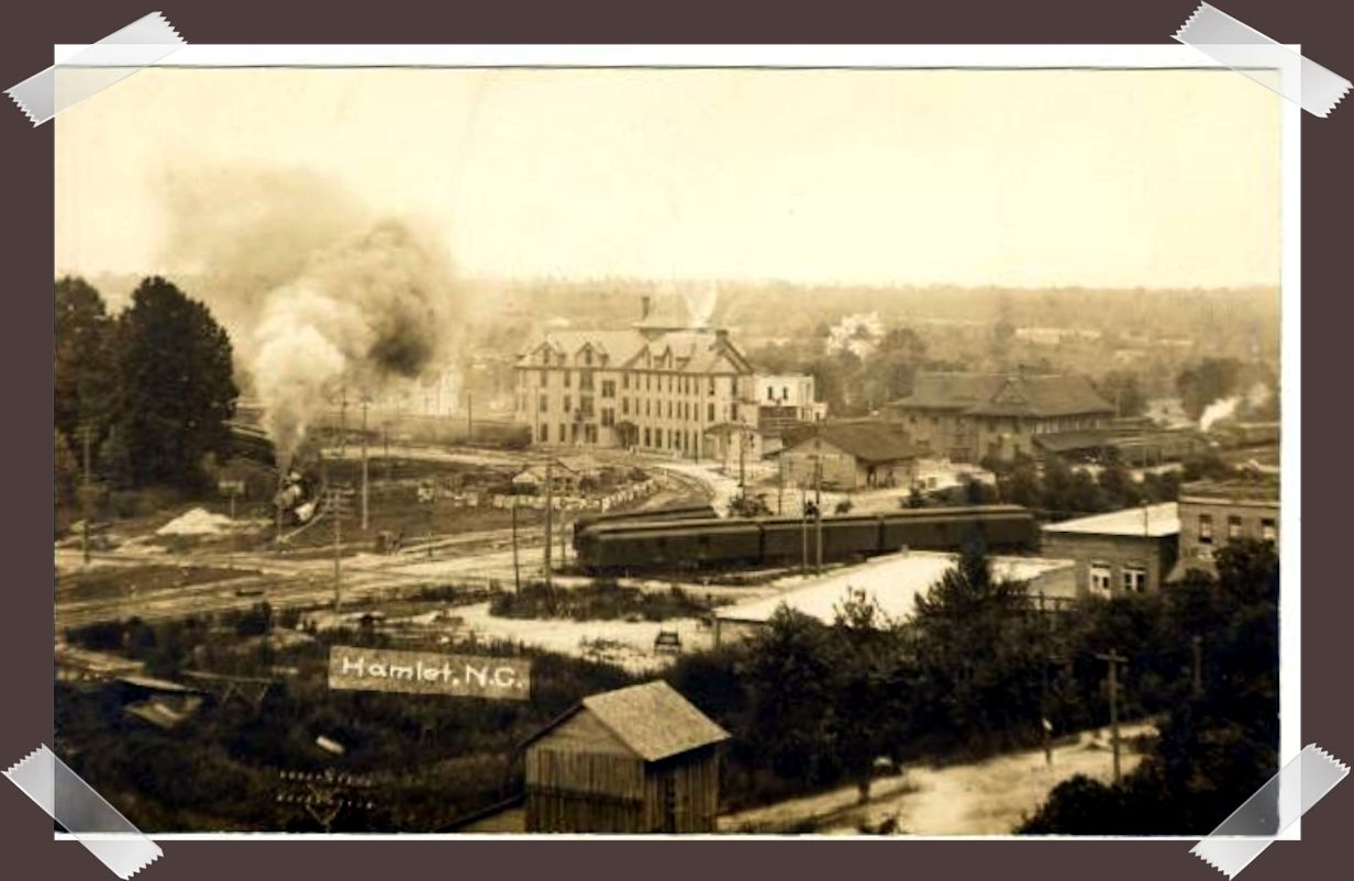
I've seen this photo a few times and always come away a little confused. Could someone get me properly oriented with this shot? Where are north and south? Is the engine (seen at the left side) coming off the north-south main line and heading west toward Rockingham? If that's the case then the terminal building looks a little strange to me because the rounded end seems to be misplaced. What was the vantage point for this shot? What was the year? HELP!
Posted: Fri May 25, 2012, 10:56 pm
by Jody Meacham
I can help with some of those questions, Bruce.
The engine on the left is, as you wrote, turning toward the west and Rockingham. There was a coal and fuel oil place inside that curve for most of the time I lived in Hamlet, and Southern National Bank was put there, too, while it existed. I don't know what that building turned into.
The depot's rotunda is at the right side of the building. A wing extends toward the camera slightly, that is to the west, and toward the Railway Express building, which was a separate structure in the photo. Later I think there was some construction that linked the express building to the station wing. The other wing extends along the north-south main line, that is directly left.
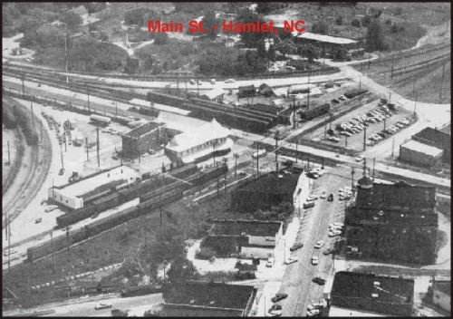
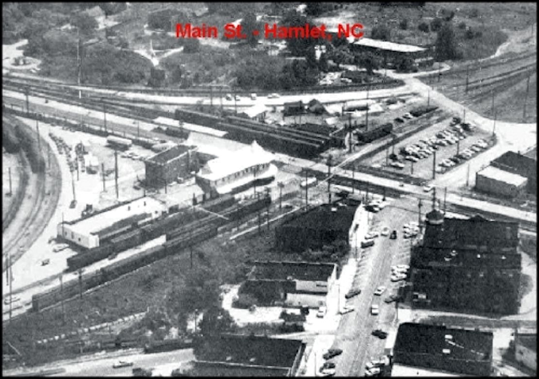
I'm guessing the photographer was on top of Pansy Fetner School on Vance Street. He was certainly elevated above ground level. The aerial photo below from David's home page is obviously from a much higher vantage point (and to the right of where the school was), but it looks generally in the same direction. The Seaboard Hotel is gone and the station is now the white color that I remember.
Dating the picture is the most difficult question because I don't see automobiles. The best clue, I think, is the Seaboard Hotel, which is the big four-story building left of the depot. I have a town history book that has several pictures of it, the latest in 1925. It burned at some point after that. If someone knows the year of the fire, that would narrow down the possible year of the photo.
I enlarged it a bit
Posted: Sat May 26, 2012, 2:27 am
by Jean Raby Nelson
Maybe someone with better eyes than me can see the cars better
Posted: Sat May 26, 2012, 9:15 am
by Jim Harris
There are utility poles in the first photograph. When did electricity come to Hamlet?
Posted: Sat May 26, 2012, 9:56 am
by Malcolm McLellan
This a view from Hamlet Hospital about 1912.
Photo by Frant Marchant. From th General
Negative Collection, N.C. State Archives, Raleigh, NC
Posted: Sat May 26, 2012, 10:55 am
by Jody Meacham
Amazing to think you could be looking at Hamlet a century ago.
Posted: Sat May 26, 2012, 1:16 pm
by Bruce Osburn
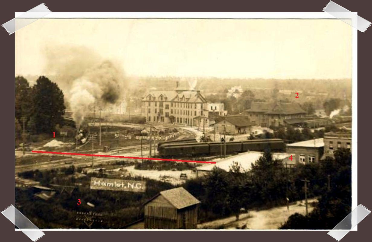
Jody cleared up some of my confusion. What had me confused more than anything else about the picture was the terminal building. The building seems to be missing the "witch's cap" (at #2).
So the orange line represents modern-day Raleigh street. But it looks more like a wagon trail than an automobile road, just a two-rut pig path.
The location of the photographer is still in doubt (at least to me). Malcolm says the photo was made from the Hamlet Hospital. But I remember that the hospital was backed up to the RR right of way, with no street in between. There are at least two utility poles visible at #3 and #4 so that leads me to believe they run alongside Vance street, which the hospital fronted. That being the case, I would guess that the photo was taken from the south side of Vance Street. Jody believes the photo was made from Pansy Fetner School. But when was Pansy Fetner (Vance Street School) completed?
#1 is where the coal pile used to be.
Who's next?
Posted: Sat May 26, 2012, 2:07 pm
by lynnsteen
I'm with you on being skeptical of the photographer's location Bruce. I don't see any way it can be Hamlet Hospital. And I don't know the history of Pansy Fetner School. But it seems to me that the position is east of the school location. If you look at the angle formed by the main east/west track line and Raleigh Street, this shot is taken at roughly a 45 degree cut of that angle. I believe the school was too far west for that angle to be possible. Something in the vicinity of the old A&P Grocery store or directly in front of that site seems appropriate to me. But I have no idea what buildings were in that area at the time.
________________
Lynn Steen
HHS Class of '60
Hamlet photo.
Posted: Sat May 26, 2012, 7:35 pm
by Jean Raby Nelson
Thant looks somewhat like a stockyard just below the hotel
Re: Hamlet photo.
Posted: Sat May 26, 2012, 7:55 pm
by Jean Raby Nelson
Jean Raby Nelson wrote:That looks somewhat like a stockyard just below the hotel
Checked google images and found this.
http://www.flickr.com/photos/north-caro ... 215630802/
old Hamlet picture
Posted: Sat May 26, 2012, 7:57 pm
by Jean Raby Nelson
So that would be the Raleigh Street crossing and there was a y behind the Main Street buildings where those cars are located. This photo would be looking at the back of the hotel
Posted: Sat May 26, 2012, 9:10 pm
by Bill Dennis
With the curve in the track going behind the hotel. I wonder if it may have been shot from the roof of the theatre.
picture
Posted: Sun May 27, 2012, 1:09 am
by Jean Raby Nelson
The photo I found on google says the pic was taken in 1907 by Marchant
Posted: Sun May 27, 2012, 1:40 am
by lynnsteen
I read the history of Hamlet Hospital which is located on this site, indicating that the hospital was started in 1915 on Vance Street. Since the archives photo info states the photo was taken from the hospital roof, this would be somewhat informative on when the photo was taken.
But I still cannot believe you could get this perspective from the roof of the hospital location that I remember from the 50s. I'm now thinking that the hospital maybe got its start in a house further down Vance Street toward Raleigh Street, closer to the vicinity of what we knew as Bennett Chevrolet in my day, and then relocated up the street as it grew. But the history I've been able to access makes no mention of a change in location in those early days, so that makes this pure speculation on my part. I still think this shot was made within a city block west of Raleigh Street because of the perspective to my eye. And for that reason I would rule out this photo being taken from the Theater roof; I think it's clearly west of Raleigh Street.
Jean mentioned the "Y" behind the Pool Room and associated buildings on Main. I agree that the railcars in the foreground are located on that Y where it comes off the main line near Raleigh Street. That Y in my day continued on across Main near Birmingham Drug presumably tieing into the southbound main lne. But it could have just been a service track for the buildings on Main.
Don't be too hard on me now folks; remember that you're dealing with a 70 year old mind here.
______________
Lynn Steen
HHS Class of '60
Posted: Sun May 27, 2012, 4:00 am
by Jody Meacham
I guessed Pansy Fetner School because it felt like from the angle of the photo, the photographer's position was east of where I remember the hospital and that was the only other tall building that I could think of in that area.
I can barely make out what appears to be the peak of the witch's hat below and slightly left of the "2." The stockyard or whatever it is also caught my attention but I've got no idea what it could be.
I remember the wye that ran behind the pool room and past Birmingham's. I think there was some sort of wooden loading and unloading ramp beside the track behind the pool room and I would occasionally see freight cars spotted there when I was young. They may have delivered rolls of newsprint for the News-Messenger.
[/youtube]
Posted: Sun May 27, 2012, 10:18 pm
by Wayne Fuller
The Y mentioned was called The Plametto Y. The Palmetto Y came off the East / Weet Main Line behind the Sanitay Laundry, crossed Main St. and connected to the North / South Main Line behind the Buttercup Plant. Could the picture have been taken from the top of the Sanitary Laundry?
Unloading
Posted: Mon May 28, 2012, 1:25 am
by Jean Raby Nelson
Yes that is where the newsprint was unloaded
Posted: Mon May 28, 2012, 9:25 am
by lynnsteen
@ Wayne
I personally think Sanitary Laundry was on or near the line of view for this shot. But I don't know that that building was tall enough for this shot; don't remember how tall that building was, but I get the sense that this shot was made from a fairly high elevation. I suspect that the picture was taken from across the street from Sanitary, but that's just speculation.
______________
Lynn Steen
HHS Class of '60
Posted: Mon May 28, 2012, 5:04 pm
by David
Maybe this was taken from the Presbyterian Church bell tower? The angle would be better as the Hospital is to close to the tracks. Maybe somebody knows if there is access to the tower?
Posted: Tue May 29, 2012, 8:58 am
by Malcolm McLellan
For those that have a copy of the Hamlet history published in 1997,
More Than A Memory. On page 42, there is a picture taken in 1904
from the Express Co. looking west from the depot area, which shows
a clear view of both the school and the hospital. I agree with Jody
that the school is the better location. Wherever the picture was
taken, it is a good picture and shows a lot about Hamlet's past.
Frank Marchant would be pleased that some of the old kids found it
so interesting.
Posted: Wed July 4, 2012, 4:59 pm
by rogersle
The picture is REVERSED! It could not have been taken from the school nor hospital. Observe the second photo. With the top of picture #2 we will call North (it is not, just for orientation), the hospital and school would be West of the depot. Another photo on McGuirt's page show the hotel would be located on the West of the depot. I have download several photos and orientated them to show this. The photo had to be taken somewhere from the direction of the overpass.
Posted: Tue July 10, 2012, 7:05 am
by Wayne Fuller
I'm thinking the picture was taken from the about the Nurses home on Main St.